Map of the Greek Islands
Greek islands map: the eight island groups, where Santorini, Crete, Mykonos, Corfu and the rest sit, which have airports, and which ferries link them.
GNTO, Greece’s national tourism organisation, sorts the islands under eight headings: the Argo-Saronic islands, Crete, the Cyclades, the Dodecanese, Evia, the Ionian islands, the North Aegean and the Sporades. How many islands that adds up to depends on who counts and how small an islet they include. GNTO’s own line is “6,000 islands and islets … of which only 227 islands are inhabited”, with no year or definition attached, while an atlas from the University of the Aegean, built on the 2011 census, counts 114 inhabited islands. How many Greek islands there are goes through the counts.
The eleven islands with a page of their own on this site sit in five of the eight groups: Santorini, Mykonos, Milos, Paros and Naxos in the Cyclades; Crete on its own; Rhodes in the Dodecanese; Corfu, Kefalonia and Zakynthos in the Ionian; and Hydra in the Argo-Saronic. Seven of them have airports with international flights. Milos, Naxos and Paros have next to none, so visitors fly in from Athens or come by sea, and Hydra has no airport at all.
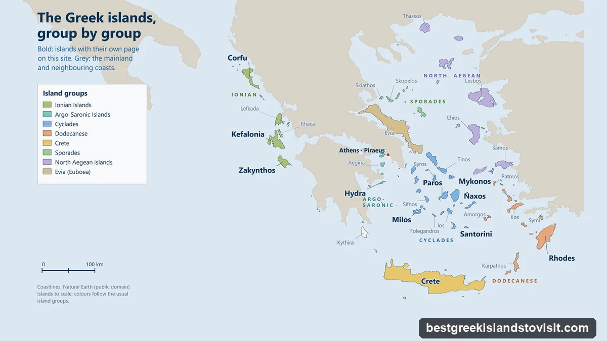
The eight island groups
| Group | Islands GNTO lists | Worth knowing |
|---|---|---|
| Argo-Saronic | Salamina, Aegina, Agistri, Poros, Hydra, Spetses | GNTO places them from the Saronic Gulf to the entrance of the Argolic Gulf; Aegina is 40 minutes from Piraeus by high-speed boat |
| Cyclades | Santorini, Mykonos, Milos, Paros, Naxos, Ios, Sifnos, Folegandros, Amorgos; also Delos, Andros, Tinos, Syros, Kea, Kythnos, Serifos, Kimolos, Antiparos, Anafi, Sikinos, Thirasia and the Small Cyclades | Named, GNTO says, for the circle they form around Delos |
| Crete | Crete | The largest Greek island, with its own heading |
| Dodecanese | Rhodes, Kos, Kalymnos, Karpathos, Astypalaia, Patmos, Leros, Tilos, Lipsi, Kasos, Symi, Nisyros, Chalki, Kastellorizo, and smaller islets | Fourteen main islands, more than the twelve in the name; Rhodes is the capital |
| Evia | Evia | The second biggest Greek island, in GNTO’s words |
| Ionian | Corfu, Kefalonia, Ithaca, Zakynthos, Lefkada, Paxi, Antipaxi, Meganisi, Kythira, Antikythira and the Diapontia islands | No ferries from Piraeus, Rafina or Lavrio; boats leave from Kyllini, Patras, Astakos and Igoumenitsa |
| North Aegean | Lesvos (Lesbos), Chios, Samos, Thassos, Limnos, Ikaria, Fournoi, Psara, Oinousses, Agios Efstratios, Samothrace | Lesvos and Chios lie off the Turkish coast |
| Sporades | Skiathos, Skopelos, Alonnisos, Skyros | Sailings from Volos, Mantoudi on Evia and Thessaloniki |
Two of the groupings follow tradition rather than administration. Kythira is listed with the Ionian islands but belongs, with the Argo-Saronic islands, to the Islands regional unit of Attica. Thassos is listed with the North Aegean but is a regional unit of Eastern Macedonia and Thrace, and you reach it from Kavala on the mainland. Skiathos, Skopelos and Alonnisos are administered from Thessaly.
Where each island on this site sits
| Island | Group | Airport | Main ports | From Athens |
|---|---|---|---|---|
| Santorini (Thira, Thera) | Cyclades, southern end | JTR (Fraport) | Athinios; Fira Old Port | 50-minute flight; 5 h 35 by SeaJets from Piraeus |
| Mykonos | Cyclades | JMK (Fraport) | New Port (Tourlos); Old Port (Chora) | 45-minute flight; 2 h 30 by Golden Star from Rafina |
| Milos | Cyclades, south-west | MLO (state-run) | Adamas | 40-minute flight; 2 h 30 by SeaJets from Piraeus |
| Paros | Cyclades, centre | PAS (state-run) | Parikia; Pounta for Antiparos | 45-minute flight; 4 h 10 to 4 h 30 by Blue Star |
| Naxos | Cyclades, the largest | JNX (state-run) | Naxos Town | 45-minute flight; 5 h 20 to 5 h 50 by Blue Star |
| Crete | Crete | Heraklion (state-run), Chania (Fraport), Sitia | Heraklion; Souda for Chania; Kissamos; Sitia | Flights; 9 h 30 overnight to Heraklion by Minoan |
| Rhodes (Rodos) | Dodecanese, its capital | RHO (Fraport) | Rhodes Town | Flights; from 15 h 40 by Blue Star |
| Corfu (Kerkyra) | Ionian | CFU (Fraport) | Corfu Town; Lefkimmi in the south | 1 h 15 flight; ferries from Igoumenitsa |
| Kefalonia (Cephalonia) | Ionian | EFL (Fraport) | Sami, Poros, Fiskardo, Pessada | Flights; ferries from Kyllini, Patras or Astakos |
| Zakynthos (Zante) | Ionian | ZTH (Fraport) | Zakynthos Town; Agios Nikolaos | 1-hour flight; ferries from Kyllini |
| Hydra | Argo-Saronic | None | Hydra harbour | High-speed boats only, 1 h 15 at the fastest from Piraeus |
Sources: GNTO for the groups and the flight times; Fraport Greece and the HCAA for the airports; the operators’ own timetables for the crossings.
Fraport Greece runs fourteen regional airports, among them Santorini, Mykonos, Rhodes, Corfu, Kefalonia, Zakynthos and Chania. Heraklion, Milos, Paros and Naxos are among the 24 airports run by the state. A new airport for Heraklion, at Kastelli, is targeted for 2028.
Islands with no airport
Of the islands people most often ask about, these have no airport at all, going by the HCAA’s list of every Greek airport with commercial flights: Ios, Sifnos, Folegandros, Amorgos, Symi, Patmos, Ithaca, Hydra, Aegina, Poros, Spetses, Skopelos, Lefkada and Thassos.
Two of them have an airport close by on the mainland. Lefkada is joined to the mainland by a floating bridge and uses Aktion (Preveza) airport, and for Thassos GNTO’s route is a 1 h 10 flight from Athens to Kavala, then a ferry of 1 h 40. The rest are reached by sea, often after a flight to a neighbour: GNTO routes Ios through Santorini (35 to 45 minutes by ferry), Folegandros through Milos and Amorgos through Naxos. In 2025, 28 airports on 26 islands had commercial traffic, from Heraklion with about 10 million passengers down to Kastellorizo with 7,602.
Which islands link by ferry
Ferries run in lines rather than a grid, and the lines mostly follow the groups.
- From Athens, Piraeus serves the Cyclades, Crete, the Dodecanese, the Argo-Saronic islands and some North Aegean lines. Rafina, close to Athens airport, has the Golden Star boats to Andros, Tinos, Mykonos, Paros, Naxos, Ios and Santorini. Lavrio is the main port for Kea and Kythnos. At Piraeus the gates go roughly by destination (E1 for the Dodecanese, E2 or E3 for Crete, E6 or E7 for the Cyclades), but assignments change, so go by your ticket.
- Inside the Cyclades the fast boats hop from island to island. SeaJets times Mykonos to Paros at 35 to 50 minutes, Paros to Naxos at 25 to 30, Naxos to Santorini at 1 h 10 to 1 h 30 and Santorini to Milos at 1 h 55. Naxos or Paros and Santorini or Mykonos cover two of the classic pairs.
- The Cyclades and Crete are joined at Santorini and Heraklion: about 1 h 35 to 1 h 40 by SeaJets or 3 h 15 to 3 h 50 by Blue Star (see Crete or Santorini). Minoan Lines also sails Heraklion to Milos.
- Crete and the Dodecanese are joined by Blue Star’s long line from Heraklion through Sitia, Kasos, Karpathos and Chalki to Rhodes. From Rhodes, boats reach Symi in 45 minutes to 1 h 30.
- The Ionian islands are a separate system. Corfu Town is 1 h 10 to 1 h 30 from Igoumenitsa, and Lefkimmi in the south of Corfu 50 minutes. Zakynthos is 1 h 15 and Poros on Kefalonia about 1 h 30 from Kyllini, and Kefalonia’s port of Sami also has boats from Patras and Astakos. Between the islands, GNTO lists Agios Nikolaos on Zakynthos to Pessada on Kefalonia at 1 h 35, Vasiliki on Lefkada to Fiskardo at an hour, and Sami to Pisaetos on Ithaca at 31 minutes.
- The Argo-Saronic islands are close to Piraeus: Aegina 40 minutes by high-speed boat or 1 h 10 by conventional ferry, Poros an hour, Hydra 1 h 15 at the fastest and Spetses 1 h 50 by way of Hydra.
- In the north, SeaJets runs Volos to Skiathos, Skopelos and Alonnisos, and Lavrio to Chios, Agios Efstratios, Limnos and Kavala; Thassos is reached from Kavala or Keramoti. Kythira has a SeaJets link to Kissamos in western Crete.
The ferry year runs from 1 November to 31 October, and some links run only in summer: Fast Ferries reaches Paros from Rafina only from 13 June to 13 September in 2026. The meltemi, the strong northerly summer wind of the Aegean, can hold ships in port; on 14 August 2026 sailings from Rafina and Lavrio were held until 16:00. Greek island hopping works through the combinations.
What are the five biggest Greek islands?
By GNTO’s own descriptions, in order: Crete, Evia, Lesvos, Rhodes and Chios. Crete covers about 8,336 km². Only Crete and Rhodes of the five have a page on this site. Evia has a GNTO heading of its own, and Lesvos and Chios lie in the North Aegean, off the Turkish coast.
Which month is best for the Greek islands?
That depends on what you want from the sea and the wind, so here are the facts rather than a pick. EMY, the national weather service, counts April to October as the warm, dry season, with the hottest spell in the last ten days of July and the first ten of August, when the mean maximum is 29 to 35 °C. The meltemi shows up in the Aegean in June and weakens in September. The Ionian islands get far more autumn rain than the Cyclades: 140.4 mm in October on Corfu, against 38.6 mm on Naxos. Out of season many hotels close: 62% of Greek hotels are seasonal, and they opened for 5.8 months on average in 2025. Lonely Planet notes that more travellers now choose May, September and October because of summer heatwaves.
Are there Greek islands to avoid?
None of the guides we read tells readers to avoid an island. What changes a trip is the state of things on the day, and as of early October 2026 these are the ones to know about:
- Navagio (Shipwreck Beach) on Zakynthos is closed to landing and swimming until 31 October 2026; boats may only pass through a buoyed viewing zone, for 20 minutes at most.
- Samaria Gorge on Crete has been closed at both entrances since 1 October, after storms, until further notice.
- Patmos and Leros were put under water-scarcity emergencies in November 2025, since extended, and Astypalaia in May 2026.
- In winter, Mykonos airport’s runway closes every Thursday from 19 November 2026 to 18 March 2027 for rebuilding, and Corfu’s closes from 20 to 28 January 2027.
Every island page on this site
- Santorini: the caldera island at the southern end of the Cyclades.
- Crete: the largest island, with Knossos and the other Minoan palaces.
- Mykonos: Chora, the windmills and the boats to Delos.
- Milos: a volcanic island in the south-west of the Cyclades, with the white rocks of Kleftiko.
- Paros: the island at the centre of the Cyclades, next to Antiparos.
- Naxos: the largest of the Cyclades, with Mount Zas, the group’s highest mountain.
- Rhodes: the capital of the Dodecanese, with a medieval town on the World Heritage List since 1988, and Lindos.
- Corfu: the Ionian island whose old town has been on the World Heritage List since 2007.
- Kefalonia: the Ionian island of the Melissani and Drogarati caves, with ferries to Ithaca.
- Zakynthos: Navagio, the Blue Caves and the turtle nesting beaches of Laganas Bay.
- Hydra: the Argo-Saronic island where cars and motorbikes are not allowed.
The smaller islands without a page here, from Folegandros and Sifnos to Ithaca, Kythira and Symi, are in the least touristy Greek islands.
Settled on an Island?
Each tour's calendar shows the dates it is actually running, with the price and that tour's cancellation terms; every tour listed here except the Lindos acropolis ticket can be cancelled for a full refund up to 24 hours before.
Compare the Tours, Island by Island